Compte rendu du SEZAM’INAIRE de Marina RABINEAU
This presentation given by Dr Marina Rabineau is the product of a long collaboration between biologists coming mainly from Nelson Mandela University – South Africa, micropaleontologist, ocean physicists including Théo Le Hir (Link his presentation) and geologists (geodynamic and sedimentology).
The goal is to compare biogeographic data and geological information try understanding mechanisms involved in reiterated colonization of Madagascar by African vertebrates and flora.
In fact, 80% of Madagascar’s fauna and flora is endemic. It means that the DNA of the concerned species evolved differently with time due to the adaptation in a unique (isolated) environment.
How did biologists managed to provide a timeframe for the evolution of species ?
The biologists had to collect and make an inventory of endemic species’ taxa. They observed different periods of speciation (120, 65, 35 and 16 million years) (Masters et al, 2020) by looking at the nucleotides, components of the DNA: the more the nucleotides deviate from the original, the more time is required.
Geological setting and theory
At -175 million years, Madagascar is still connected to the African plate (Somalia, Kenya, and Tanzania), so it is normal that common ancestors existed. Through the action of plate tectonic, the island was separated from Africa and drifted to the south and stopped at -120 million years. From -120 million years up to present day, the two lands are separated by a 450km body of water, which is the Canal of Mozambique.
The common explanations have long been that the animals traveled on trunks or branches and with the help of the oceanic currents reached the shore of Madagascar. New paleo-oceanography reconstitution models showed that it would take between 70 to 90 days to do the travel. Quite impossible without food and water for the vertebrates.
What are the relationships between the colonization of the flora and fauna with the local and global geology?
Recent geological studies show that vertical movements are underestimated. Vertical movements can be related to rifting phase, tectonic and thermic subsidence that affected the margin and the oceanic basin. On the other hand, there are some uplifts recorded in the sediments onshore and offshore. Volcanic edifices also create high reliefs that are then submitted to subsidence.
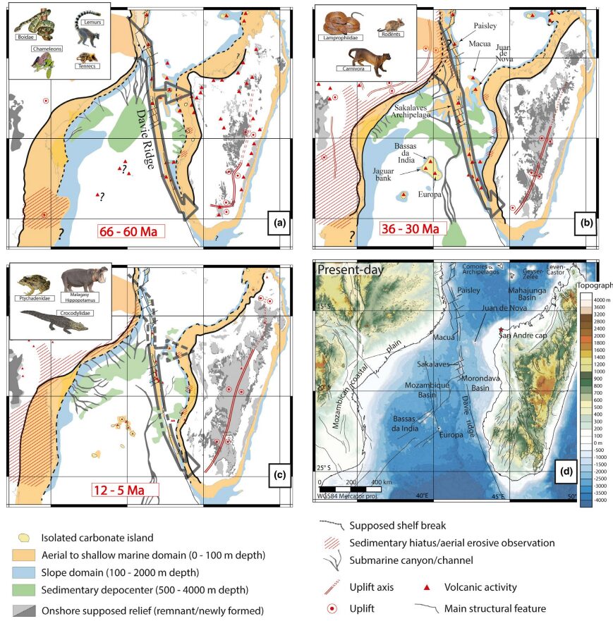
This movements are resulting in the variation of elevation of the Davie ridge from shallow to deep water. Three shallow phases were identified and created a pathway for the vertebrates: 66 to 60 million years ago (Lemurs, chameleons), 36 to 30 million years ago (rodents, carnivora) and 12 to 5 million years ago (crocodiles and hippopotamus). The last one was not continuous hence, only amphibian animals could cross (Masters et al, 2020 cf: see figure 1).

Traces of pollens and dinoflagellates were found in a core located on the west side of Madagascar. Dated around 10 million years ago (Miocene – Messinian) they correspond to mangroves (very shallow environment) and high-altitude trees from Madagascar (Aslanian et al, 2023). This assumption is based on general wind circulation and the location of the sample on the east side of the ridge that constitutes a barrier for sediment transportation from Africa.
Now, the challenge is to study new pathways around the world for a better understanding of the speciation related to global geodynamic events.
Louanne and Hector, floating university.
References :
-Aslanian et al (2023) The postulation of intermittent land bridges as an explanation for reiterated colonization events of Madagascar by African vertebrates: An in-depth review and novel insights in honor of the late Judith Masters and Fabien Génin – Earth science review, 246.
-Masters et al (2020) Biogeographic mechanisms involved in the colonization of Madagascar by African vertebrates: Rifting, rafting and runways. – Journal of Biogeography
 Attention, vous utilisez un navigateur peu sûr !