English version of Theo LE HIR’s SEZAM’INAIRE
Théo LE HIR’s presentation discussed many physical aspects of the ocean in the Mozambique channel and his modelling in paleo-environmental conditions. His PhD subject is a collaboration between the LOPS (Laboratoire d’océanographie Physique et Spatiale) and the laboratory Geo-Ocean in Brest.
400 km of oceanic basin separates Madagascar from Africa since 125 million years. However, some vertebrates such as lemurs have succeeded to reach Madagascar from Africa during this period. Knowing that lemurs cannot swim, the first hypothesis to explain their migration is that they crossed the ocean on natural rafts. In 2016, the PAMELA mission allowed to realize a reconstitution of the Mozambique channel at different stages of the Cenozoic. It showed a Davie’s ridge (a major geological structure in the region globally oriented North-West/South-East along the Western Malagasy margin) emerged, suggesting a possible temporary terrestrial bridge between the continent and Madagascar. This questions the rafting hypothesis of the lemurs.
After a description of the actual Agulhas system in the South-West of the Indian Ocean, Théo explained the interest of simulating the ocean at high resolution (some structures of ~100 km such as the rings of the Agulhas current have important impacts on the global circulation) with the limits that this imposes in terms of calculation costs.
Théo’s aim is to use numerical modelling to determine the impact these bridges would have had on the past circulation of the South-West Indian Ocean.
The first step of his work was to realize a sensibility test of the regional circulation with a closed Mozambique channel. This test was made at high resolution (1/12°). This results in significant changes in the transport (the water flowing North of the canal intensifies the current South of Madagascar), in the turbulences, in the vertical structure of the Agulhas current, in the water bodies and in the ground currents.
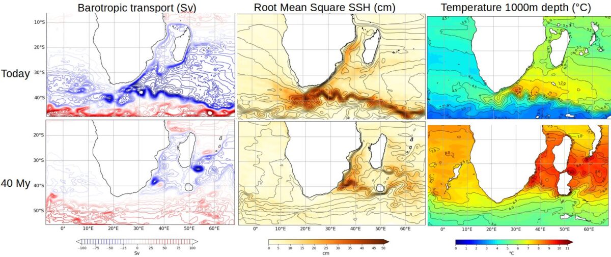
At the time when the Davie’s ridge was hypothetically emerged (~35 Ma), the climate and the currents were very different from today : warmer climate, no ice, African plate further South, radically different connectivity between the ocean.
The IPSL (Institut Pierre Simon Laplace) realized some global simulations coupled with low resolution paleo-geographical data and have been able to provide to Théo the data he needed to make a regional simulation (bathymetry, winds, heat flows, initial state, etc). This allowed him to launch a first paleo simulation (at first without the bridge) whose results are very interesting in terms of transport and very different from current simulations.
His next step is to realize a similar paleo simulation but this time with a closed Mozambique channel. He is hoping to get significant differences to analyze.
Melina BOULIC
 Attention, vous utilisez un navigateur peu sûr !