Vos questions !
Dans cette rubrique, vous trouverez les questions reçues pendant notre mission en mer et nos réponses à celles-ci.
24 avril 2022 – Nicolas depuis Paris
Bonjour,
Pourquoi le Marion-Dufresne navigue vers le nord depuis hier, donc plus au nord que sur la carte initiale.
A la rencontre d’un tourbillon ?
Bonne continuation, bonjour à bord, et bravo pour les pages et informations sur le site RESILIENCE en ligne.
Nicolas
Bonjour Nicolas,
merci pour ton message! C‘est vrai que notre itérinaire n‘est pas toujours évident donc je vais essayer de te donner une petite explication.
Pour rappel, l‘objectif de Leg 1 était d‘étudier des processus de biologie, chimie et physique qui sont liés …. (oups j‘ai changé de langue mais non je ne peux pas en français.)
Hello Nicolas,
thanks a lot for your message :). You have keen eyes, yes, effectively our itinerary is constantly changing! But there are good reasons for it, let me try to explain to you why we deviated from our initial plan.
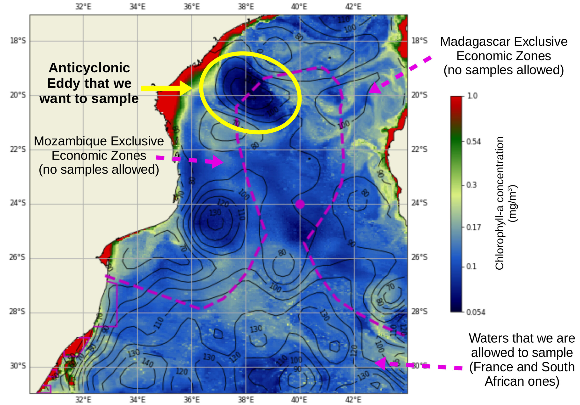
Remember, objective at Leg 1 was to study the biological, physical and chemical processes associated to an anticyclonic eddy (a rotating feature rotating counter-clockwise in the southern Hemisphere) in the northwestern part of the Mozambique Channel.
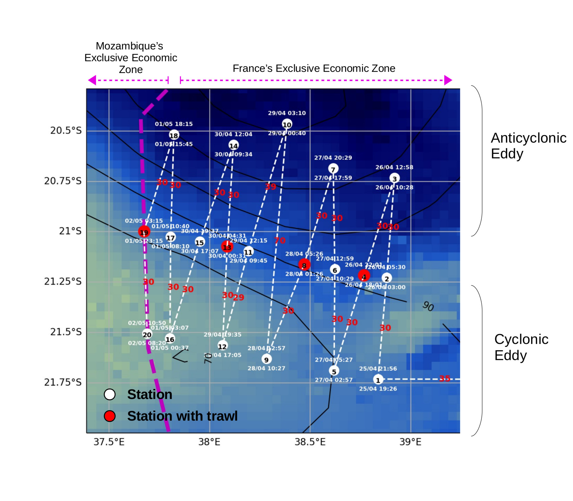
For our study we are taking probes from different areas between the center of the eddy and the outer parts which are connected to volumes of water with different properties (so called fronts, as seen in Picture).
But here comes the tricky part: The eddy itself does not only rotate but it also moves in space and time („from A to B“). The direction and speed of the eddy‘s movement is influenced by many factors. The multitude of factors makes the precise prediction of where it is moving a little tricky. This is why we have to update and adjust our plan everyday (if we want to take samples in and around the center of the eddy and its fronts). In order to update our plan, we use mostly satellite imaging. From satellite images we can get information such as the sea-surface height (SSH), sea-surface temperature (SST) and the colour of the ocean (indicator of phytoplankton biomass). All of these factors help us to determine where the eddy can be found so that we can take our samples with respect to where the eddy is situated. And in the case for your specific question the eddy did move northwards so we just followed it for our sampling! Essentially you already answered the question yourself, but hopefully I could add some more interesting details (in this page of our blog we added a summary of the Leg 1 scopes and sampling’s evolution).
If you have any more questions let me know, we are sending a fresh breeze and sunshine from the south-african coast your way, wishing you a wonderful day.
UF Correspondante 😀
 Attention, vous utilisez un navigateur peu sûr !